
DES BARRES, J.F.W. (1721-1824)
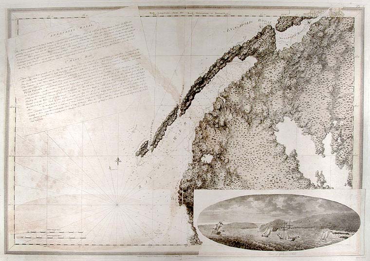
Annapolis Royal... St. Mary's Bay
London: Published by J.F.W. Des Barres in 'The Atlantic Neptune', 1 January, 1781. Etching with added hand-colour. On laid paper with 'J Bates' watermark and 'JB' countermark. Sheet size: 31 3/4 x 47 inches.
A fine print from "The Atlantic Neptune" which charts the Annapolis Royal, with a coastal view of Gulliver's Hole and a descriptive text.
'The Atlantic Neptune' was the first great marine atlas, and one of the greatest achievements of eighteenth century cartography. Published in England in 1774, it contained over 250 charts and views of the North American and Canadian coasts. The charts were intensely detailed and contained both hydrographical and topographical details. The Neptune was compiled and published for the Royal Navy by Joseph F. W. Des Barres, a Swiss cartographer who joined the Royal American Regiment as a surveyor. Des Barres fought in the French and Indian wars and was enlisted to survey the Canadian coastline. While his fellow surveyor, Samuel Holland charted the New England coast, Des Barres mapped the shoreline of Nova Scotia, Newfoundland and the St. Lawrence River regions. In 1774, Des Barres returned to England where he compiled and published his monumental atlas; his dedication to the project was so strong that he published an updated version of the work every year until 1784. Des Barres' work was so superior to any other contemporary atlas, that the maps were used as the standard charts of the East coast for over 50 years. The Neptune remains one of the most important atlases ever printed, its views and maps chart the history of North America and allow us to glimpse a forgotten land long changed by the passage of time. This chart is an excellent eighteenth century record of the first settlement in Canada. In 1605, two years before the first permanent English settlement at Jamestown, three years before the founding of Quebec, and fifteen years before the Pilgrims landed at Plymouth, a small party of French explorers, led by Sieur de Monts, established Port Royal as the first settlement in Canada. The settlement was later renamed Annapolis Royal which is the name asigned to it in Des Barres chart.
Spendlove, The Face of Early Canada, Chapter 4: "J.F.W. Des Barres and The Atlantic Neptune"; pp. 18-22; Debard, "The Family Origins of Joseph Fredericks Wallet DesBarres: A Riddle Finally Solved", Nova Scotia Historical Review, Vol 14, No. 2 (1994), p.15.
Item #5598
Price: $3,500.00